Deploying & Running Approximate Geospatial Query Processing at Scale on Microsoft Azure HDInsights
Overview
This tutorial shows an example of how to run an approximate geospatial stream processing application on an Azure HDInsights cluster deployed with Apache Spark and Kafka- you will learn how to:
- create Azure HDInsight clusters deployed with Apache Spark & Kafka.
- run an example dynamic application scenario common in smart city applications.
Prerequisites
- Microsoft Azure subscription.
- basic knowledge of Jupyter Notebooks.
- basic knowledge of Scala programming language.
- basic knolwedge of Kafka topics.
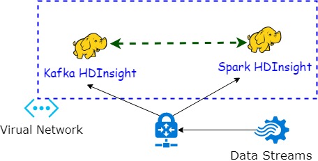
Microsoft Azure Spark and Kafka HDInsight clusters need to be deployed within the same virtual network.
This tutorial exploits a template for this purpose. This allows the Spark cluster to communicate directly with Kafka.
📓 Click here to continue reading the full tutorial 📓
The challenge
- Large amounts of georeferenced data streams arrive daily to stream processing systems.
- This is attributable to the overabundance of affordable IoT devices.
- Interested practitioners desire to exploit Internet of Things (IoT) data streams for strategic decision-making
However, mobility data arehighly skewedand theirarrival rates fluctuate. This nature poses an extra challenge on data stream processing systems, which are required in order to achieve pre-specified latency and accuracy goals.
- Approximate Query Processing (AQP) over massively-arriving streams of geospatial data is becoming essential.
The solution
- In this post, I will show you how to easily deploy and run an interactive QoS-aware framework in
Microsoft Azure, for performing AQP approximate processing of geo-referenced mobility data, at scale with quality of service guarantees.
- We will focus on stateful aggregations (e.g.,
means,counts) andtop-Nqueries. - The example code has the ability to strike a plausible balance between latency and accuracy targets.
- We will focus on stateful aggregations (e.g.,
- The deployment includes Apache Spark Structured Streaming and Apcahe Kafka communicating directly within the premises of a virtual network.
- In short, geospatial AQP is esential for dynamic application scenarios prevalent in smart cities and urban informatics. The example we show in this post can deliver real accurate results in a timely manner, by employing a qualified QoS-aware geospatial startified-like online sampling method that we have designed.
Isam Al Jawarneh
Assistant Professor
My research interests include big data management (Cloud & Edge), large-scale geospatial database systems,context-aware recommender systems, data warehousing & data lakes.